Featured Story
Mangroves move inland as seas rise
Adapting to the damaging effects of climate change, plants are gradually moving to where temperatures are cooler, rainfall is greater, f...

Showing posts with label Earth Observations. Show all posts
Showing posts with label Earth Observations. Show all posts
8/20/2015
Argentina: Spider Webs, Spider Webs Everywhere!

1/24/2014
Mystifying "Pillars of Light" Descend From Ohio Sky

Well, according to National Geographic, light pillars are vertical columns of light that form when artificial or natural light bounces off the faces of ice crystals floating relatively close to the ground.
According to the University of Illinois' Weather World 2010 project, these ice crystals typically fall horizontally to the ground and have hexagonal plate-like shapes.
This phenomena was recently observed in Ohio.
See the National Geographic article on light pillars here. You can also check out the University of Illinois' Weather World 2010 project where it covers light pillars here.
WKYC News
1/14/2014
Sea froze so fast that it killed thousands of fish instantly


The dog owner says that he has never seen such a phenomenon. NRK claims that the herrings were chased by cormorants into the bay when the deadly freezing happened. Aril Slotte—the head of pelagic fish department at Norway's Institute of Marine Research—says it is not uncommon for herring to get very near the shore when chased by predators, sometimes getting trapped by the low tide in areas like this bay.
11/15/2013
Geological Rift That Baffles Scientists Is Still Expanding
 |
| A 500-metre-long crack opened up in just a few days in Afar, Ethiopia, in 2005 (Photo Credit: University of Rochester) |
It occurred in the course of a few days, in 2005 and the rift is still expanding.
According to recent reports, particularly those from the University of Addis Ababa, Ethiopia, the rift is steadily expanding and will allow a new ocean to form and separating East Africa from the rest of the continent.
"The ocean's formation is happening slowly, likely to take a few million years. It will stretch from the Afar depression (straddling Ethiopia, Eritrea and Djibouti) down to Mozambique," professor Atalay Ayele, lead researcher at the Addis Ababa University explained.
|
The seismic movements observed in Ethiopia are very similar to the changes
normally caused by faults and fissures on the seafloor,
where the processes moving tectonic plates usually start
However, this time it is happening violently and very fast.
Dr. James Hammond, a seismologist from the University of Bristol, says that parts of the region are below sea level and the Indian Ocean is only cut off by about a 20-meter strip of land in Eritrea: "Eventually this will drift apart.... The sea will flood in and will start to create this new ocean. It will pull apart, sink down deeper and deeper and eventually... parts of southern Ethiopia, Somalia will drift off, create a new island, and we'll have a smaller Africa and a very big island that floats out into the Indian Ocean." As the researchers explained, after last known eruption of Dabbahu in 2005, a volcano located in the remote Afar desert of Ethiopia, magma pushed up through the middle of the rift area and began "unzipping" the rift in both directions. The entire eastern part of the African continent has been affected by the strong forces. Both small and large cracks can be found. Photo Credit: Cindy Ebinger/University of Rochester "We know that seafloor ridges are created by a similar intrusion of magma into a rift, but we never knew that a huge length of the ridge could break open at once like this," says professor Cindy Ebinger of Department of Earth And Environmental Science, University of Rochester. Message to Eagle |
9/27/2013
Extent of BP oil spill's damage to sea-floor life "astounding"
 |
| This April 21, 2010 file photo shows oil in the Gulf of Mexico, more than 50 miles southeast of Venice on Louisiana's tip, as a large plume of smoke rises from fires on BP's Deepwater Horizon offshore oil rig. / AP Photo/Gerald Herbert, File |
Pollution and damage to animal life was severe nearly two miles from the wellhead and identifiable more than 10 miles away, Paul Montagna wrote in a report published Tuesday in the online journal PLOS One.
Montagna, a professor of ecosystems and modeling, said the refrigerator-cold water a mile beneath the surface means oil takes longer to decay than in shallower waters, where spill recovery has taken years to decades. That means full recovery could take a generation or more, he said in an interview Tuesday.
8/14/2013
Greenland ice sheet IS melting but much of the heating is coming from INSIDE the earth
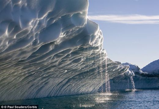 |
| In total, the Greeland ice sheet contains an amount of ice that would lead to a rise of global sea level by more than seven metres, if completely melted |
Ice in Greenland is melting partly because of heat from the Earth's mantle, according to a team of international researchers.The group claims that they are the first to find a connection between melting of the Greenland ice sheet and the high heat flow from the Earth’s mantle.The findings, they suggest, could have implications for future predictions on climate change and the reasons behind ice melt in the region.
6/27/2013
Researchers find ocean seafloor is covered in trash

Not surprising, but sad nonetheless
We've all seen images of trash on beaches, or floating on the surface of the ocean. But a surprising amount ends up on the deep seafloor, at depths so great that it's been very hard for us to really know what the situation is. Because it's no very practical to fund a deep sea mission just to look for trash, researchers at the Monterey Bay Aquarium Research Institute instead decided to comb through thousands of hours of video recorded by remotely controlled vehicles over the past 20+ years, specifically looking for debris.3/12/2013
'Penguins' survival at stake as Antarctic ice disappears

Penguins’ Survival At Stake, There are serious changes taking place here at the bottom of the world. Increasingly, experts say, the ice is disappearing at a disturbing rate in the Antarctic Peninsula and that in turn impacts the future — and perhaps the very existence — of at least half of the world’s 18 penguin species, who depend on ice and frigid waters that support krill, the penguin diet mainstay. “When cheetahs or lions get hunted, or elephants decline, there’s a big uproar. And I think, because you see penguins in large numbers [in some places] people are ignoring the larger rate of their decline,” said Oxford University penguinologist Tom Hart. “The general public doesn’t realize the penguins are declining so fast.” But it’s not just the penguins we have to worry about, Hart says, it’s the health of the planet itself. “The last wilderness on Earth is impacted by us now,” he said, describing the region’s decline as a “grave indicator” of what’s to come. It’s the end of the breeding cycle for most penguins here as summer comes to a close.
12/22/2012
Hawaiian island slowly dissolving
 |
| Oahu from space. Credit: NASA Earth Observatory |
Sometime in the distant future the mountainous tropical island will be reduced to a flat, low-lying island similar to Midway, scientists at Brigham Young University reported Friday.
While external erosion is the primary force that wears down mountains, that's not the case on Oahu, they said.
"We tried to figure out how fast the island is going away and what the influence of climate is on that rate," BYU geologist Steve Nelson said. "More material is dissolving from those islands than what is being carried off through erosion."
That was the result from comparing groundwater against stream water to see which removed more of the total quantity of mineral material mass that disappeared from the island each year, the researchers said.
"All of the Hawaiian Islands are made of just one kind of rock," Nelson said, referring to the volcanic composition of the islands. "The weathering rates are variable, too, because rainfall is so variable, so it's a great natural laboratory."
While Oahu is at present still growing, after about 1.5 million years the force of groundwater will eventually triumph and the island will begin its descent to a low-lying topography, the researchers said.
UPI
12/10/2012
AMAZING STRATOSPHERIC CLOUDS OVER EUROPE
 |
The cloud was brightly coloured at high altitude, changing continuously for about 45 mins near and after sunset
 |
"These are nacreous
clouds," explains atmospheric optics expert
Les Cowley. "Of all Earth's clouds they are
most spectacular, and a very rare treat for skywatchers."
"For up to an hour after sunset
or before dawn they glow like eerie electric discharges
or gas jets in the darkening sky, their filmy
shapes slowly curling and uncurling with intense
shifting colors. They are composed
of tiny ice crystals more than twice as high as
ordinary clouds, 9-16 miles up, in the stratosphere
and form at temperatures of minus 85 Celsius and
below. The crystals are all of similar size and
they diffract
the high altitude sunlight to make the colours."
"Search for nacreous clouds at
high latitudes (e.g., Scotland, Scandinavia, Iceland,
Northern US) in winter and preferably downwind of
mountains," Cowley advises. "They like
stormy weather that perhaps creates gravity
waves to loft the necessary moisture to make
them upwards across the tropopause
into the stratosphere. Once seen they are never
forgotten!"
10/09/2012
Subtropical Dry-Zone Is Expanding South

10/02/2012
Great Barrier Reef losing coral cover
 |
| Part of Australia's Great Barrier Reef photographed from space. Credit: NASA |
Although the reef is one of the world's most protected marine environments, its coral cover has declined from 28 percent to 13.8 percent in the past 27 years, with two-thirds of the decline occurring since 1998, researchers from the Australian Institute of Marine Science reported.
The scientists writing in the Proceedings of the National Academy of Sciences said storm damage was responsible for 48 percent of the decline while crown-of-thorns starfish -- voracious consumers of coral -- contributed 42 percent.
Coral bleaching caused by rising water temperatures accounted for another 10 percent of coral loss.
"We are basically losing an ecosystem that is so iconic for Australia and the rest of the world," institute scientist Katharina E. Fabricius told The Washington Post.
The study findings will be "a shock to the system" that could force Australians to focus on the issue, a U.S. researcher said.
"If anyone's going to do it, it's going to be the Australians, because they really care about the Great Barrier Reef," Nancy Knowlton, a coral reef biologist at the Smithsonian Institution National Museum of Natural History, said.
At the current rate of coral cover decline, researchers said, the Great Barrier Reef would lose half of its remaining coral cover by 2022.
"It will be really very low in 10 to 15 years," Fabricius said.
UPI
9/29/2012
Arctic warming faster than before
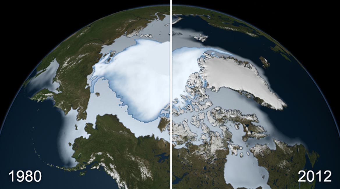 |
| NASA finds thickest parts of Arctic ice cap melting faster |
The current spike in the region's weather far outstrips previously recorded warm periods in the medieval era, a study quoted in the Geology journal says. The study was funded by the U.S. National Science Foundation and the Keck Geology Consortium.
Recent measurements indicate the arctic is warming twice as fast as the rest of the planet, with sea ice this summer shrinking to its smallest extent on record.
Natural feedbacks are amplifying the warming as loss of reflective sea ice causes the ocean to absorb more of the sun's energy, melting more sea ice, which causes more energy absorption, and so on.
9/12/2012
Caribbean coral reefs face collapse
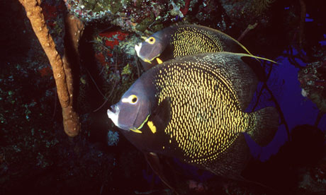 |
| A pair of French angelfish enjoy the coral reef in the Caribbean Sea. Photograph: Marcus Mays for the Guardian |
With so little growth left, the reefs are in danger of utter devastation unless urgent action is taken, conservationists warned. They said the drastic loss was the result of severe environmental problems, including over-exploitation, pollution from agricultural run-off and other sources, and climate change.
9/06/2012
A Great Silence Is Spreading Over the Natural World
 |
| Musician and naturalist Bernie Krause has spent 40 years recording over 15,000 species in many of the world's pristine habitats. (Photograph: Courtesy of Hachette Book Group) |
Bernie Krause has spent 40 years recording nature's sounds. But such is the rate of species and habitat loss that his tapes may become our only record of the original diversity of life
"The birds are silent in the woods.
Just wait: Soon enough
You will be quiet too"
- Robert Hass
When musician and naturalist Bernie Krause drops his microphones into the pristine coral reef waters of Fiji, he picks up a raucous mix of sighs, beats, glissandos, cries, groans, tones, grunts, beats and clicks.Musician
and naturalist Bernie Krause has spent 40 years recording over 15,000
species in many of the world's pristine habitats.
The water pulsates with the sound of creatures vying for acoustic
bandwidth. He hears crustaceans, parrot fish, anemones, wrasses, sharks,
shrimps, puffers and surgeonfish. Some gnash their teeth, others use
their bladders or tails to make sound. Sea anemones grunt and belch.
Every creature on the reef makes its own sound.
But half a mile away, where the same reef is badly damaged, he can only pick up the sound of waves and a few snapping shrimp. It is, he says, the desolate sound of extinction.
But half a mile away, where the same reef is badly damaged, he can only pick up the sound of waves and a few snapping shrimp. It is, he says, the desolate sound of extinction.
8/17/2012
Arctic megastorm is so powerful it’s turning the ice cap into “slush”

6/23/2012
2012 Noctilucent Cloud Season Begins
 |
| Flying photographer Brian Whittaker photographed these NLCs over Canada on June 13, 2012. Image Courtesy of Brian Whittaker. View Larger |
These electric-blue ice clouds hang 53 miles (85 km) above Earth's surface, at the edge of space itself, circling the north and south pole regions. AIM has helped clarify the mystery of how they form, including information on the required temperatures and water vapor necessary in the atmosphere.
Observing tips: NLCs favor high latitudes during the summer months, although they have been sighted as far south as Colorado and Virginia. Look west 30 to 60 minutes after sunset when the Sun has dipped 6-16 degrees below the horizon. If you see luminous blue-white tendrils spreading across the sky, you may have spotted a noctilucent cloud.
Source: NASA
6/08/2012
Huge Cloud Hole Photographed by Satellite
 |
| A high pressure system created this enormous cloud hole photographed off Australia on June 5, 2012. CREDIT: NASA |
NASA's Aqua satellite caught an arresting image of a strange, enormous weather system off the coast of Tasmania June 5, featuring a cloud hole wider than 620 miles (1,000 kilometers) at one point.
Analysis by NASA scientists found that the hole was caused by sinking air associated with a high pressure system off the surface of the Great Australian Bight, a huge bay to the continent's south. The oval-shaped hole was cut out from a blanket of marine stratocumulus clouds.
High pressure systems often bring fair weather and clear skies, and that's just what this one did, in spectacular fashion. "You could call it an anti-storm," said NASA atmospheric scientist Patrick Minnis in a statement.
In general, winds blow outward from areas of high pressure. As a result, areas of high pressure pull air downward. As the air sinks it also grows warmer, increasing the rate of evaporation and making it difficult for the air to hold clouds.
High pressure systems — which are sometimes called anticyclones — can yield large circular areas of clear skies. Areas of low pressure, by contrast, pull air upward and generate clouds and stormy weather, often producing circular cyclonic storms and clouds.
Sea-level pressure maps published by the Australian Bureau of Meteorology June 5 showed that the shape of the cloud hole matched the shape of the high pressure area.
According to NASA Goddard atmospheric scientist Joanna Joiner, weather models predicted the cloud formation nearly perfectly. "We checked the Global Modeling and Assimilation Office (GMAO) forecast, and it really nailed the system," Joiner said.
Source: Our Amazing Planet
6/07/2012
Earth nearing 'tipping point,' study warns
 |
Our planet is heading toward a sudden breakdown, a group of international scientists warn, unless humans adopt more sustainable practices. |
"There is a very high possibility that by the end of the century, the Earth is going to be a very different place," study researcher Anthony Barnosky told LiveScience. Barnosky, a professor of integrative biology from the University of California, Berkeley, joined a group of 17 other scientists to warn that this new planet might not be a pleasant place to live.
"You can envision these state changes as a fast period of adjustment where we get pushed through the eye of the needle," Barnosky said. "As we're going through the eye of the needle, that's when we see political strife, economic strife, war and famine." [ Top 10 Ways to Destroy Earth ]
4/16/2012
Giant Sinkhole In Sweden Keeps Expanding!
 |
| The enormous sinkhole at Malmberget is expanding. This is an image showing the giant pit from above. |
This is a real and dangerous phenomenon. New shocking images clearly show the enormous pit in Sweden is expanding.
The 200 foot wide open pit is called the "Fabiangropen" (Fabian pit) and is in the Malmberget area is located at Gällivare, 75km from Kiruna, Sweden.
Subscribe to:
Posts (Atom)