Just
how bad was this winter? Bad. Really, really bad as this terrifying
visualization of global temperatures during these last few months shows.
Top image: Visualization of the polar vortex this winter / NASA's Goddard Space Flight Center with video and images courtesy of NASA/JPL
NASA
put together this look at the record-breaking cold temperatures it's
been monitoring this winter using infrared sensor 3,000 feet above the
earth's surface. As you can see, we began December with a pretty normal
polar vortex lingering over top of Canada and the Arctic. Things
started to unravel in late December, and by early January, there's a
single line of arctic air stretching straight from the North Pole clear
down to Florida.
So
what happened to cause it all? NASA scientist Eric Fetzer explains how a
low pressure system in Canada's Hudson bay and an unusual movement of
the jet stream conspired to drop temperatures in this video:
The unusually sharp kink in the
jet stream that has brought extreme weather to nearly the entire U.S. in
January is finally beginning to straighten out, and a return to more
normal winter conditions will begin today and extend into next week.
After a morning low of 14°, Atlanta's
temperature is expected to rebound into the upper 30s under sunny skies
on Thursday afternoon, helping to melt out the hundreds of miles of
ice-covered roads left by Winter Storm Leon on Tuesday. A state of
emergency remains in effect for all of Georgia until at least noon
Thursday due to icy roads. Atlanta, Birmingham, Alabama,
and many other cities in the Southeast U.S. suffered their worst
traffic days in history on Tuesday, after sleet and snows of 1 - 3"
compacted into ice on area roads, resulting in travel chaos.
Temperatures will fall into the teens again on Thursday night, allowing
those roads that do thaw out to re-freeze. The Southeast will not fully
thaw out until Friday afternoon, under sunny skies and temperatures in
the 50s. Image Above: Abandoned cars litter the roadway
Cobb Parkway (US 41) between Cumberland Pkwy and W. Paces Ferry Road.
Image credit: Michael King @mhking
Top snowfall amounts from Leon, by state VIRGINIA:
10.0” at 5 locations in the Norfolk-Virginia News area; Park Manor,
Suffolk, Stone Bridge, Deep Creek, and Willoughby Spit (8.5” officially
at Norfolk NWS site) NORTH CAROLINA: 9.0” Gliden NEW JERSEY: 7.7” Estell Manor (7.3" in Atlantic City) MARYLAND: 6.7” Ridge MASSACHUSETTS: 5.5" East Sandwich, West Tisbury DELAWARE: 5.4” Dover, Harrington, Ellendale NEW YORK: 4.9" Theresa MISSISSIPPI: 3.0” at 5 sites, including Cato SOUTH CAROLINA: 4.0” Bennetstsville GEORGIA: 4.0” White LOUISIANA: 4.0” Jena ALABAMA: 3.0” numerous locations WEST VIRGINIA: 3.0" Gary TENNESSEE: 2.0" Maryville PENNSYLVANIA: 1.0” 5 NE Philadelphia FLORIDA: no official snow reports, but 0.5" of sleet at Freeport Image Above: Snowfall in Florida. Is this the new norm?
Rain in California! "Ahhh,
rain!" Those are words that undoubtedly arose from the lips of a great
number of upturned faces in California on Wednesday, as heaven-sent
drops of water splashed down from above. The first significant rain
storm of 2014 moved through the northern half of the state on Wednesday,
bringing some welcome relief from the record dry conditions that have
parched the state this winter. In the Sierra Mountains, snows of up to
12 inches fell, and up to 2 feet of snow may accumulate above 8,000
feet, adding a modest boost to a snowpack that was the lowest on record
in many locations. As of 7 am PST on January 30, the Sierra Snow Survey found a snow pack that was only 7% of normal for this time of year. Sacramento
recorded 0.03" of rain on Wednesday, ending a string of 52 consecutive
days without rain. It was their longest streak of dry days during the
rainy season ever recorded, smashing the previous record of 46 days set in 1884.
According to wunderground's weather historian Christopher C. Burt,
Wednesday's rains in downtown San Francisco and Oakland ended their
longest winter rain-free periods on record, since at least 1850 (though
San Francisco did get 0.03" of drizzle earlier this month.) The last
actual rainfall in the city was on December 6th. That’s 53 days during
what normally should be the wettest period of the year, when at least 8”
would normally fall. Yesterday's rains also brought an exceptional dry
streak to an end in Reno, Nevada--the 0.10" of rain that fell was its
first precipitation since December 19.
Drought situation in California still dire despite today's rains While
yesterday's and today's rains and snow in California are a welcome
respite, they will put only a minor dent in what is one of the worst
droughts in California history. Today's U.S. Drought Monitor
update put 9% of the state into "Exceptional Drought"--the worst
category. This is the first time since the Drought Monitor product began
in 2000 that a portion of California was put into "Exceptional
Drought". California's area experiencing extreme to exceptional drought
remained at 63%, making it one of the three worst winter droughts in
state history. To break the drought, much of the state needs
more than 12" of precipitation. Sacramento has received about 2" of
rain since July 1, 2013, which is 8" below normal, and most of the
southern half of the state needs more than a year of rainfall to fall in
one month to break the drought. The stubborn ridge of high pressure
responsible for the drought is forecast to build back over California
during the first ten days of February, and the state will receive little
or no rain during that period. However, the ridge will not be as
intense, increasing the odds that a low pressure system will be able to
break the ridge by mid-February and bring more rain to the state. Image Above: The January 29 U.S. Drought
Monitor showed 94% of California in drought, with 9% of the state in the
highest level of drought, "Exceptional." Image credit: U.S. Drought Monitor.
Waves crash against the sea wall near high tide in Scituate, Mass., Jan. 3, 2014.
Record-low chilling temperatures are predicted to blast parts of the
Great Plains, extending to the Eastern seaboard, while a second winter
storm is expected later Saturday through Monday.
Factoring in wind chill, temperatures as low as 50 to 70 degrees
below zero are forecasted in the Northern Plains and Upper Midwest by
Sunday night, according to the National Weather Service. At least 16 deaths have been linked to weather across Michigan, Kentucky, Indiana and Illinois, USA TODAY reports.
Emergency officials warn that such startling temperatures could lead to
frostbite or even hypothermia in a matter of minutes. One man died
outside his Milwaukee home, where temperatures surged below zero in
Wisconsin.
Meteorologists attribute the “polar vortex” to freezing air from the
North Pole being pushed down to as far as the Gulf Coast of the U.S.,
the Associated Press reports.
In Atlanta, temperatures will be in the mid-20s by Tuesday while a
wintry mix of rain and snow are expected in parts of Kentucky,
Tennessee, West Virginia, northern Arkansas, southern Ohio and
southwestern Pennsylvania late into Sunday. The cold front will likely
freeze large bodies of water, like the Great Lakes, meaning freezing
temperatures could last through winter.
While still digging out from current snowfall, another winter storm
will drop more snow and ice onto the the central Plains to the Great
Lakes states this weekend. The biggest hit areas will include St.
Louis, Indianapolis, Detroit, Cleveland and Buffalo.
Minnesota Gov. Mark Dayton canceled school statewide Monday, due to
the frigid weather, for the first time in 17 years, while schools also
closed as far south as Washington, D.C.
At least 2,200 flights were canceled across the country Friday,
adding to the already 2,300 canceled Thursday. Airlines are bracing for
more cancellations Saturday, which included 765 more canceled flights as
of 7 a.m., according to FlightStats.com.
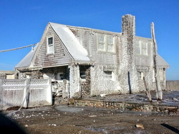
Oceanfront home encrusted in ice in Scituate. #wbz#wbznews
In case you weren't sure what climate change looks like, here's a
preview: It looks like millions of people displaced from their homes due
to flooding. For example, in 2012, when 32.4 million people had to
leave their homes due to disaster, the majority of whom were displaced
by flooding from monsoons and typhoons in Asia.
The Norwegian Refugee Council operates the Internal Displacement
Monitoring Centre, the focus of which is to track how and where such
displacement occurs. Its estimates for 2012, released today,
indicates that the year's total comprises 22 percent of displacements
since 2008. Sixty-eight percent of the displacement was as the result of
what the IDMC calls a "mega event" — an event that displaces at least a
million people. Ninety-eight percent of all displacement was due to
climate- or weather-related events.
Victims beg for food after deadly Philippine typhoon
Desperate families begged for food Sunday, days after a typhoon brought
death and destruction to parts of a southern Philippine island, as the
storm returned to the north of the country.
Northern areas escaped with heavy rain after the storm weakened. But
scenes of hardship were everywhere in southern areas that last week felt
the full fury of the strongest typhoon to hit the country this year.
Officials said 548 people are confirmed dead, most of them in the southern island of Mindanao.
Civil
defence chief Benito Ramos said the number of missing had shot up to
827 from previous figures of 500 unaccounted for, after reports of more
missing fishermen came in.
Cars are submerged at the entrance to a
parking garage in New York's Financial District in the aftermath of
superstorm Sandy. Picture: Richard Drew
NEW York has awoken in shock to a city devastated by deadly superstorm Sandy, which killed at least 10 people and threatened to leave days of chaos in its wake.
A record tidal surge thrown up by the hurricane set off an explosion at a power station, fire destroyed dozens of homes in the Queens district and a major hospital had to evacuate more than 200 patients at the height of the storm.
Subway trains and buses remained suspended for a third day and hundreds of thousands of homes face up to a week without electricity, the power company warned.
Unpredictable weather has altered bird migration patterns, with many arriving in Wales weeks earlier than expected, say experts.
The National Wetland Centre in Llanelli said 800 curlews, not normally seen until late August, were early arrivals.
About 100 redshank, 90 oystercatcher and 190 black-tailed godwit had also flown in early.
The Wildfowl and Wetlands Trust (WWT) said the weather also affected breeding patterns.
Another reason for the birds' early arrival might be that some of them failed to breed in Iceland.
Pamela Styles, the WWT's learning assistant at Llanelli,
said: "2012 has been a year of unpredictable weather, and many birds
have already been affected.
Add captionA dock extends into a dry cove at Morse Reservoir in Noblesville, Ind.,
on July 5. The central Indiana reservoir is down 3.5 feet from normal
levels. Michael Conroy / AP file
From exploding hay bales to a sprinkler ban in Indianapolis, the
Midwest and Plains states continue to be tested by a hot, dry summer.
A
drought update Thursday didn't offer much hope either: 61 percent of
the contiguous U.S. was listed in drought, up from 56 percent last week,
according to the National Weather Service's Drought Monitor.
"Anytime
we have a drought maturing in mid-summer, the chances for rapid
intensification will be there," Gary McManus, Oklahoma's associate state
climatologist, told msnbc.com. "Even normal heat and dry conditions can
speed that drought along."
WASHINGTON (AP) -- Nature is pummeling the United States this year with extremes.
Unprecedented
triple-digit heat and devastating drought. Deadly tornadoes leveling
towns. Massive rivers overflowing. A billion-dollar blizzard. And now,
unusual hurricane-caused flooding in Vermont.
If
what's falling from the sky isn't enough, the ground shook in places
that normally seem stable: Colorado and the entire East Coast. On
Friday, a strong quake triggered brief tsunami warnings in Alaska.
Arizona and New Mexico have broken records for wildfires.
Total
weather losses top $35 billion, and that's not counting Hurricane
Irene, according to the National Oceanic Atmospheric Administration.
AUSTIN, Texas — The
swath of states across the southern U.S. burned hot on Wednesday:
Little Rock, Ark., beat its all-time record, reaching 114 degrees.
Sweltering Texas saw a third-straight day of record electricity usage.
Phoenix, Ariz., also saw triple digits — and the possibility of yet
another dust storm.
Little Rock topped its earlier record, set in 1986, by two degrees.
In Texas, the power-grid operator urged residents to conserve electricity or face the prospect of rolling blackouts.
Three extreme weather stories to take you into the long holiday weekend in the US to which you probably should be paying attention: 1) Fire continues to threaten Los Alamos National Laboratory and its store of radioactive waste stored (shockingly) in drums outside; 2) the drought in Texas is so bad that the entire state has been declared a disaster area; 3) ongoing drought in the Horn of Africa and East Africa is sending masses of what are essentially climate refugees from Somalia into Kenya. Democracy Now reports that some 10 million people in Djibouti, Ethiopia, Kenya, Somalia and Uganda have been affected by the drought, which has been described as the worst in 60 years and in some areas near-famine conditions exist.
The UN's Mark Bowden says, "Unless we are able to take action now, I think that we are likely to see not just more migration, but a level of deaths in Somalia that takes us back almost 20 years and certainly has been unparalleled in the recent decade."
BOSTON -- Last week temperatures in Boston neared 100 degrees in early June.Just days before, three Massachusetts residents were killed by a deadly string of three powerful tornadoes that tore across the western part of the state, inflicting tens of millions of dollars in property damage in more than a dozen Massachusetts communities, including Springfield, Monson, Sturbridge and Brimfield.It will be months before many families can recover.
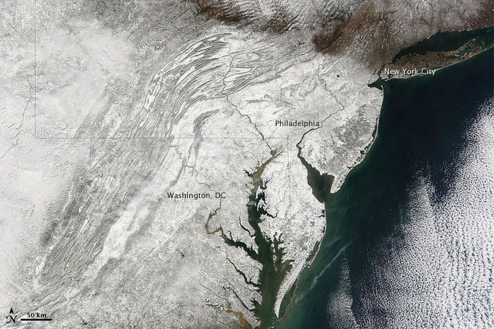
Satellite image of the blizzard over the northeastern US on Dec. 27, 2010, CREDIT: NASA/GISS
Earth's atmosphere showed a mean streak in 2010, and there may be more to come.
Along the East Coast of the United States, buried under the avalanche of this week's blizzard (above) in New York City, are the memories of "Snowmageddon" -- the big Nor'easter that in the first week of last February dumped record snowfalls on major cities in the Mid-Atlantic region, from Wilmington to Washington. SEE ALSO: Snowmageddon Brings Icicles of Doom
(Reuters) - Around the globe, the weather has turned extreme, driving up prices for commodities running the gamut from sugar and wheat to heating oil and orange juice.
Australia, for instance, is suffering from both extremes -- with drought in the west and deluges in the east. Heavy snow in Europe and sub-freezing temperatures in the United States are likewise fuelling the weather rally in commodities.
Fires in Queensland, flood warnings in Victoria, a foot of snow in the mountains and Sydney's BIGGEST DUST STORM IN LIVING MEMORY - this is Australia. Weather was the talking point across the continent on Wednesday, with a severe cold front delivering BIZARRE conditions. At Perisher, high in the NSW ski fields, they are expecting a spring blast of snow, anticipating up to a foot of snow by Saturday or Sunday.
In southeast Queensland, firefighters worked to snuff out blazes on the Sunshine Coast. High temperatures and gusty winds have prompted authorities to impose a total fire ban through almost half of Queensland. In Victoria, the opposite is playing out with a maximum of 15 degrees predicted for Saturday.
While it's been a little calmer in Perth, the conditions have still been odd. Winter rain that has continued into September in Australia's southwest has meteorologists searching the record books to find a longer spell of unbroken wet weather. Perth's Wellington Dam on Tuesday broke through the 50 per cent mark for the first time in 12 years and 11 of the southwest's 23 dams are overflowing. Long-standing Perth residents cannot remember such unseasonal rain, while the weather bureau says this month's falls represent THE LONGEST RECORDED STRETCH OF DAILY SEPTEMBER RAIN SINCE 1915.
The rain is predicted to return next week. Meanwhile, up to 120mm of rain fell in some areas of Tasmania in the 24 hours to 9am on Wednesday. The downpour caused flooding and cut power to more than 1,000 homes. The heavy rain, which was forecast to ease in the afternoon, comes after one of the state's WETTEST WINTERS ON RECORD.
Winter was snowier, summer was hotter and storms were UNUSUALLY FREQUENT in the Arctic this year, leaving several records shattered and some wondering if the extreme weather is a sign of what’s to come. Kotzebue experienced its HOTTEST JULY SINCE THE 1940s when the city began keeping records. The average temperature for the month was 66 degrees — that’s 5.3 degrees warmer than normal — and UNUSUALLY DRY as well. August looks to be a record-breaking month as well, with a high so far of 67 degrees on Aug. 5. “Normally in August the first week or two is cool, then we warm up and then in the end there is a cooling trend into September. But we were almost 20 degrees warmer the first week of August than we were last year.”
If it wasn’t enough that the city is getting baked, it’s also been smelling smoke from forest fires in the interior drift north and northwest. It’s been so bad, the state’s Department of Air Quality advised that young children, the elderly and the sick stay inside, and healthy people avoid prolonged outdoor activity. Barrow had its sixth warmest July, but it’s also been the FIRST TIME THAT THE TEMPERATURE DIDN'T DIP TO FREEZING AT ANY POINT DURING THE MONTH. There were also a few stand-out days — Barrow had its warmest July 12, at 73 degrees, and July 30, at 72 degrees. July 28 tied the previous record of 70 degrees. Barrow’s highest temperature ever was 79 degrees, recorded on July 13, 1993. “It’s a big thing that has happened, especially in July. There is usually maybe one day a year when we have high temperatures in the 70s."
With the summer heat came another UNUSUAL kind of weather — thunderstorms along the coast of the Northwest Arctic. When a hot day erupted into a stormy evening in Kotzebue on June 22 "people were shocked. No one could remember back to when there was a real honest thunder and lightening storm in Kotzebue. I had people calling me up asking ‘is this really happening?’ ” While storms are common in the Selawik Valley, it is RARE that they make it to the coast, where cool weather blows off the ocean. Kivalina got hit with stormy weather as well, which is UNUSUAL. The Northwest is being influenced by a ridge of high pressure that’s locked in eastern Alaska. That ridge makes the atmosphere in the east too stable for storms, but has warmed up the west just enough.
The hot summer came on the heels of a winter that pounded Arctic communities with huge snowfalls. Barrow got 77.9 inches of snow over the course of the year, which is almost triple the 28 inches it usually gets. But that was hardly anything compared to what Kotzebue got. A whopping 47.4 inches got dumped on Kotzebue in February alone, more than nine times the historical average. At least one inch of snow fell during 13 different days in February, 10.7 inches on the last two days. Kotzebue usually gets 49.4 inches in an entire winter. “So, Kotzebue essentially received nearly A YEAR'S WORTH OF SNOW IN 28 DAYS". The drifts only got deeper in the beginning of March, when 21.6 inches fell in just the first 10 days, four times the monthly average. Snowy winters and hot summers might seem like an unlikely pairing, but last winter was fairly warm, and warmer winters are more favorable to snowfall because the atmosphere can hold more water.
It was 77.9 degrees for Medford in July, the HOTTEST JULY SINCE 1911 when the National Weather Service began keeping records here. There were five RECORD TEMPERATURES, including two new record highs, 108 degrees on July 28, and 109 on July 29. There were also three new records for the warmest daily low temperature — 69, 69 and 68 on the last three days of the month. July was even drier than it normally is. Rain is always rare in summer, and whatever moisture comes usually arrives as a thundershower. This year, the only moisture that fell at the Medford airport was a trace on July 8, when the temperature dipped briefly overnight to 49 degrees, the lowest for the month.
CANADA - Temperatures soared well above the 19 C average the last week of July, toppling records. Tuesday, July 28 boasted a high of 29.5 C, which was the WARMEST TEMPERATURE FOR THAT DATE ON RECORD. On Wednesday it got as hot as 30.7 C, Inuvik's HOTTEST JULY 29 ON RECORD. It came just a few degrees short of the town's all-time high of 32.8 C, which occurred on two occasions: June 17, 1999 and July 20, 2001. Thursday's high of 29.5 C just missed the 1976 record for that day, 31.1 C. They can thank the desert regions of the U.S. for those surprisingly balmy days. "I'm a bit surprised that the air has had legs. It moved all the way up without being modified. There's been no cooling. It came from the west and not from the south. Some summers that just doesn't happen."
Whitehorse set an ALL-TIME RECORD FOR THE MONTH OF JULY, on July 29 when the temperatures soared to 33.1 C. The hot air has made its way through Vancouver, northern B.C., then along to the Yukon. "British Columbia and Yukon (are) under this ridge of very high pressure, it's very extended and its very huge. It's flowing eastward and engulfing northern parts of the Northwest Territories, which would include you, and not getting down where the Canadian air is in the southern parts of the Territories." "Our forecast for all of the Northwest territories through August is warmer than normal; September and October will also be warmer than normal."
You know the weather is truly wonky when Canada's king of climatology suggests heat-seeking Manitobans head NORTH to work on their summer tans. "If you really want it warm, try the Yukon or Nunavut. Their temperatures have been about 12 degrees higher than normal." Indeed, Whitehorse's high of 32 C earlier this week put the northern capital on par with Miami and parts of Spain. Meanwhile, Winnipeg just narrowly escaped being named the summer's weather misery capital of Canada. "It was a toss-up between Winnipeg, Ottawa and Montreal. I was leaning toward Winnipeg because the last time it was warmer than normal there was in November of 2008." (Ottawa took the crown by having the WETTEST JULY IN ITS HISTORY). Not only was Manitoba's spring UNUSUALLY cold and wet, summer seems to be heading in the same direction. They've already had 40 per cent more rain than usually falls in July. Daily highs this time of year should be in the mid-20s, but temperatures have been at least two degrees colder than average. The entire country -- aside from the B.C. Interior, which has hit temperatures in the 40s -- is colder, wetter and darker than normal. Canada's UNUSUAL weather patterns are being caused by a cool jet stream, which typically stays around the northern territories and northern Quebec, but has decided to hang out farther south. Unfortunately, normalcy won't likely be returning for August and September -- at least not to Manitoba.
Sand dunes had been advancing for decades, and two years ago, they finally swallowed the houses of 13 families in Ilha Grande, an island in the Parnaiba river delta in northeastern Brazil. "It is beautiful now, but beauty brings misery. The cause of this is natural, but it is man-made as well." Experts blame deforestation and population increases for the huge dunes that are advancing by about 25 metres a year, threatening to wipe the town of 8,500 people off the map. But they and residents also blame stronger winds and drier weather in recent years. "The wind has been getting stronger. It is the motor of this process." Image: An aerial view of a flooded farm in the northeastern state of Maranhao. A bout of extreme weather, including floods in the north and drought in the south, has reignited the debate about how climate change is affecting Latin America's largest country, home to the world's biggest rain forest and one of the world's bread baskets.
A bout of extreme weather has reignited a debate about how climate change is affecting Latin America's largest country, home to most of the world's biggest rain forest and one of the world's bread baskets. Unusually heavy rains in the north and northeast have made hundreds of thousands of people homeless and killed about 45.
Meanwhile, southern Brazil has been hit by a series of droughts, devastating farmers and cutting by a third the flow of water over the famed Iguacu waterfalls. "Brazil is feeling climate changes that are happening in the world, when there is a severe drought in a place that didn't have them, when it rains in places where it didn't used to." "We are seeing the warming and we are seeing conditions in many parts of the country that appear to be associated." Southern states have suffered droughts in seven of the past 11 years and the first hurricane recorded in Brazil hit the southern coast in 2004. The Amazon area had its worst drought in decades in 2005.
Warming also plays a key role in models of a so-called "tipping point" in which drier weather and deforestation combine to turn much of the Amazon forest into a savanna and possibly cut the flow of rain to southern farming states. About half of the forest is "teetering on the edge" of not having enough water to survive the more intense dry seasons. The drying process, which raises the amount of destruction by fires, is on course to release about 20 billion tons of carbon into the atmosphere over the next two decades, about twice the current annual total of global emissions.